


Wonders of our World #6
#6 in my list of world wonders revised for the modern world


As beings inhabiting the present, we have always yearned for the ability to predict the future. Over the millennia, not much has affected our ability to survive and thrive more than the weather. Many religious traditions from around the world emphasize ritual sacrifices in order to please gods in control of the weather and the harvest. Throughout history, humans have held near-universal fear that the god’s fury would be expressed in droughts, storms, floods, or the cold death of winter. When we finally were able to view weather from the perspective of the heavens, we gained a much greater ability to plan our lives around it.

In April of 1960, the worlds first weather satellite, TIROS I, launched from Cape Canaveral, Florida and the world was never the same again. Using data collected from space, the scientists of the National Weather Service (Then the Weather Bureau) were able to issue the first air pollution advisory over the Eastern U.S. In 1961, the National Severe Storms Center was founded in Kansas City, and in ‘63 TIROS III began automatically transmitting cloud images to over 100 nations on a continuous basis. With the advent of weather satellite technology, meteorology made great progress, no doubt saving millions of lives along the way. No longer would people exclusively rely on almanacs that could at best predict weather conditions within a range of +/- 10 degrees within time periods of two or three weeks. With active monitoring of in-situ conditions, predictions began to approach levels of accuracy and speed that made them akin to divination. People in the path of an irregular major storm could be warned in advance, allowing them to board their windows, and evacuate, saving lives and infrastructure along the way. That’s why my pick for the 6th wonder of the world is the network of weather satellites that orbit the earth.
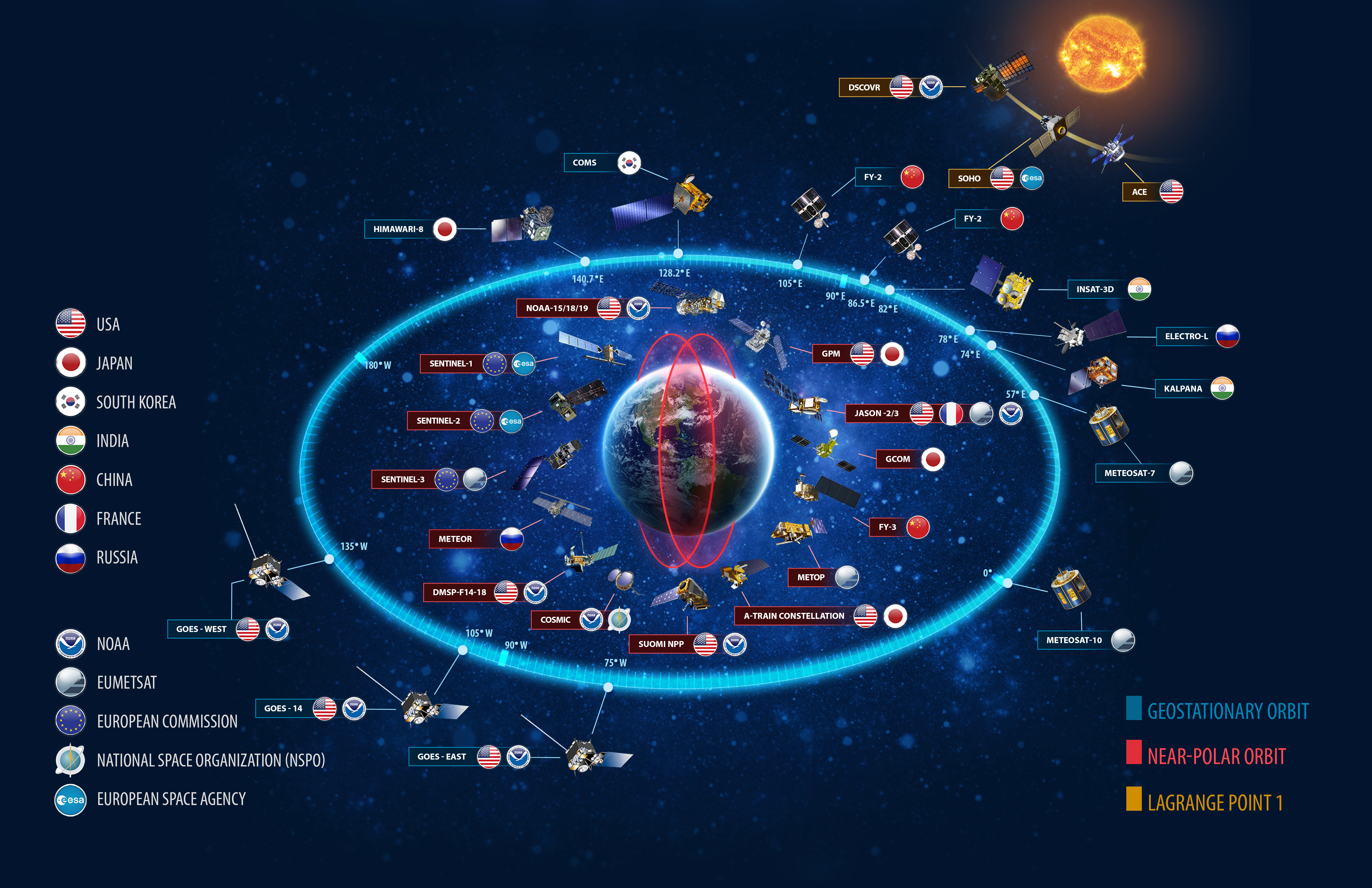
Things have changed a lot since TIROS I was put into service, and with the advent of digital computing and advancements in communications and launch technologies, satellites have become more commonplace. Pictured above is the WMO Global Observing System, which is made up of 12 satellites in geostationary orbit, 14 in near polar orbit, and 3 at LaGrange point 1, which monitor space weather like solar flares and coronal mass ejections. Of these satellites, 12 are US built, including all of the space weather array, the EU and China each maintain 3, with 3 additional for Europe from nonstate orgs like EUMETSAT. Also of note is the near polar orbiting COSMIC satellite, which is a joint venture between NOAA and NSPO (National Space Organization) which is the Taiwanese civilian space agency.
The distinction between geostationary and polar orbiting is important to understand. Geostationary orbiting satellites inhabit high altitude orbits close to earth’s equator, and orbit at the same angular rate as the earths rotation, meaning that they are continuously above the same section of earth. They essentially take continuous data from a single perspective and use the differences from to monitor the changes in cloud formations and track storms development over time within their viewing window. They are also used to track large scale dynamic phenomena such as wildfires and sandstorms. There are also solar synchronous orbits, which are similar, except their position is locked relative to the Sun, so while they do move over the earth, they always return to the same place at the same relative solar time. For example, a SSO would be useful if you wanted to take a picture of Paris every day at solar noon. Often times satellites maintain a solar synchronous orbit that allows them to avoid the earth’s shadow in order to ensure 24/7 operation of their solar arrays.
Polar and near polar orbiting satellites orbit at lower altitudes around the North and South poles and monitor the entire earth, cycling back around between every 10 days to 1 month depending on their speed. They are mainly used to do weather forecasting, and for monitoring more regular patterns such as the seasons, glacial growth/recedence, and other situations where you would need intermittent data over long time periods.
LEO or low earth orbit satellites are one of the more common types of satellites, however because of the crowdedness of LEO and the difficulty of managing so many orbital paths at once, these orbits are mainly reserved for constellations of communications satellites, like Elon Musk’s Starlink network. Medium Earth Orbits are common for navigational satellites that power systems like GPS and other mapping software. Pictured above is the WMO Global Observing System, which is made up of 12 satellites in geostationary orbit, 14 in near polar orbit, and 3 at LaGrange point 1, which monitor space weather like solar flares and coronal mass ejections. Of these satellites, 12 are US built, including all of the space weather array, the EU and China each maintain 3, with 3 additional for Europe from nonstate orgs like EUMETSAT. Also of note is the near polar orbiting COSMIC satellite, which is a joint venture between NOAA and NSPO (National Space Organization) which is the Taiwanese civilian space agency.
In the past week you may have seen the image below circulating around twitter, which depicts the heatwave currently striking northwest India and Pakistan. Surface temperatures are expected to reach 60 degrees Celsius in some areas, and hundreds of thousands will face heatstroke, drought, and death. While this isn’t comparable to global deaths related to cold (see here for a ACX thread on how a warming climate might save lives), the increased volatility of the climate still poses significant risks to human life, as cultural adaptations to climate insulate many of us from the worst effects, and are slow to adapt.

The 2022 Indian heatwave is just one of many weather phenomena that have put millions of lives in danger over the millennia. Storms, heatwaves, cold snaps, all have the capacity to kill us if we are not properly equipped to deal with them. However, we are more prepared today than ever to anticipate, track, and respond to weather phenomena, thanks to the Global Observing System and other similar ground based monitoring networks. The early warning and informational dissemination that comes with the G.O.S. and other weather satellites is invaluable in giving people the initiative they need to prepare their homes to last out the event or even evacuate if necessary, and will only become more so in the future.
As climate change continues to exacerbate the severity of meteorological events all around the world, one of the best things we can do to reduce its negative impacts is to gather and disseminate high quality information to allow people, markets, and governments to be as prepared as possible to adapt to the dynamic conditions of the world we live in. That’s what earns the global weather satellite network the #6 spot in my list of the Wonders of our World. Stay tuned as we count up the list in upcoming posts, and comment below what world wonders you think should make the list!
-Connor, OfAllTrades.
Liked this article? Please Subscribe!
Know someone else who would? Share with a friend!
And if any of you readers out there are secretly crypto millionaires and would like to leave a tip, please check out https://alltrades.eth.xyz/
Predicting the weather is one thing, but we'll have the best predictions when we can control the weather. What kind of technology would we need for that? Would we need to be full Kardashev 1 scale or could we do it sooner?